Find and localize
any road assets
with simple text
prompts
any road assets
with simple text
prompts
Asset Inspection


Unlimited mileage,
results in 48 hours
results in 48 hours

Record video using
a simple smartphone
a simple smartphone
1


Search for assets using text input
2
Roadly will identify and localize objects in 3D
3

Navigate within the online platform or opt for data export
4


Roadly will identify and localize objects in 3D
Navigate your road network at your desk
3
Search for assets using text input
2
Navigate within the online platform or opt for data export
4

Record video using
a simple smartphone
a simple smartphone

1

Receive a comprehensive evaluation of a sample road segment,
complete with detailed analysis of its condition.
complete with detailed analysis of its condition.
5 miles of the PCI Inspection
are included in our free trial
are included in our free trial
Receive a comprehensive evaluation of a sample road segment, complete with detailed analysis of its condition.
5 miles of the PCI Inspection are included in our free trial
Demo map: See in action
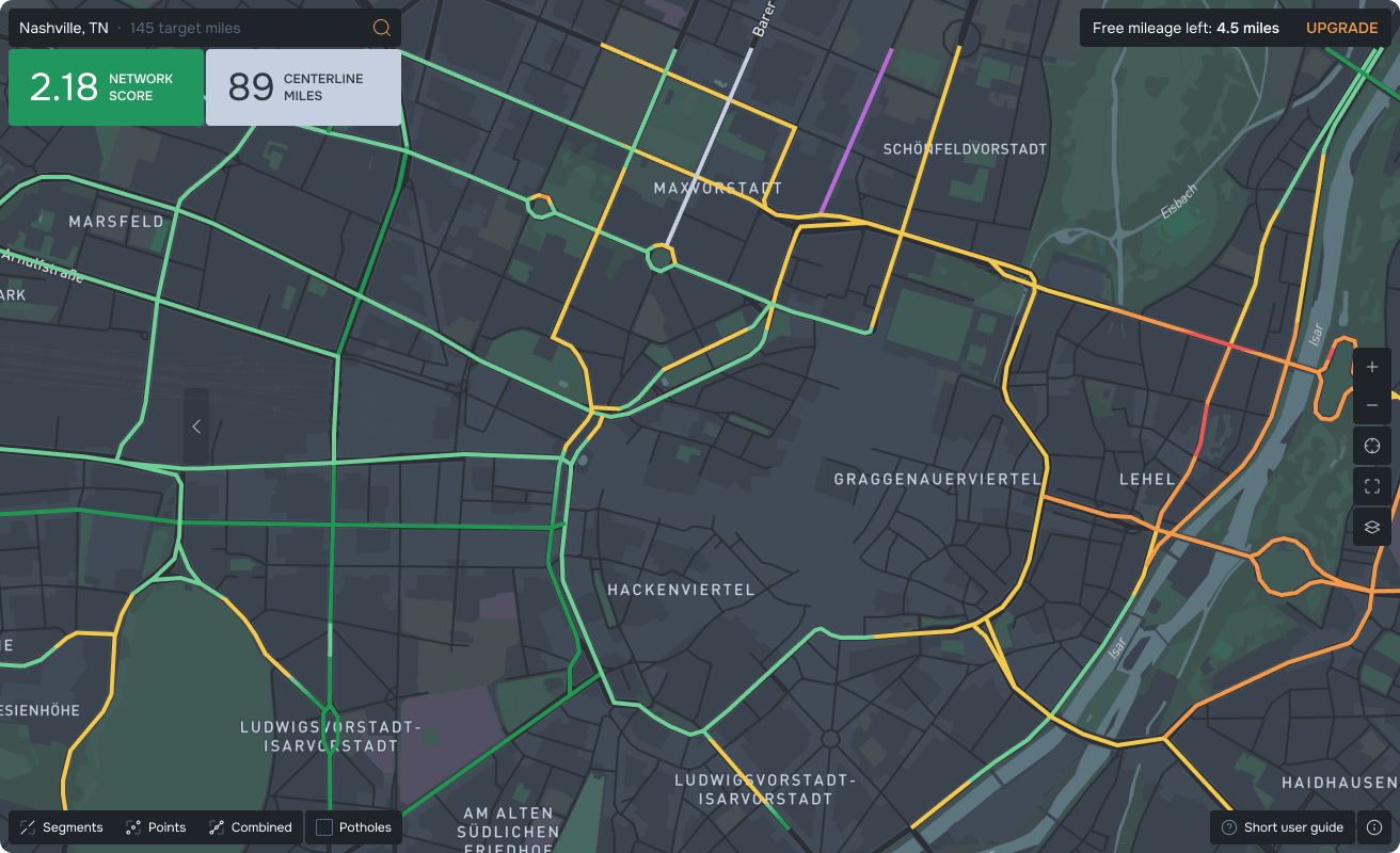

City of Nashville DOT:
pavement inspection
pavement inspection
Minnesota DOT:
traffic signs inventory
traffic signs inventory
Roadly case studies
NYS DOT: inventory
of reference markers
of reference markers
NYS DOT:
guardrails inventory
guardrails inventory
Leveraging our advanced 3D Map engine, we construct a centimeter-accurate Digital Twin of all your assets.
Precise Digital Twin
By utilizing smartphones in dashcam mode, we significantly reduce the costs associated with data collection and processing.
Cost Efficiency
Roadly ensures your Asset Management database is rapidly and regularly updated, providing you with the most current information.
Up-to-date data
The captured road imagery is mapped onto Roadly, our interactive online platform. Roadly enables you to conveniently view assets and assess conditions directly from your desk.


You no longer have to worry about doing manual data collection or using costly LIDAR-based solutions.
Roadly app enables employees to effortlessly capture high-definition imagery and GPS information while driving their roads. After driving, the collected data is then uploaded to the cloud for analysis by Roadly.
Roadly app enables employees to effortlessly capture high-definition imagery and GPS information while driving their roads. After driving, the collected data is then uploaded to the cloud for analysis by Roadly.
Why Roadly?
Technology
Value
Roadly provides a comprehensive approach to:
Maintaining your critical road assets
Inspecting the condition of your assets
and understanding which of your assets are in poor condition and need to be removed or replaced, damaged beyond repair or missing entirely
and understanding which of your assets are in poor condition and need to be removed or replaced, damaged beyond repair or missing entirely
Confidently allocating funds and plans
for repairs and replacements
for repairs and replacements
Roadly can process your photolog imagery collected by ARAN or other vehicles from previous years to build and update your asset inventory.
Already have existing imagery and visual data?